 |
| Our route from Cape Town to the Fish River Canyon and back via the Sperrgebiet |
It was October 1970. On the spur of the moment, Noelin and I were invited on a road trip from Cape Town, our home town, to the Fish River Canyon in Namibia. The route would take us Northwest via Springbok and O'Kiep across the Orange river to the Richtersveld National Park. Our host and guide was a dear friend, Fred, and our transport, Fred's ancient and battered Opel station wagon. We had four days to cover over 2000 km. I used my Nikon F with 50mm f2.0 Nikkor-H loaded with Kodacolor X to document the trip. Fred used his Hasselblad with 80mm f2.8 Zeiss Planar T and 50mm f2.8 Zeiss Distagon loaded with Kodak Tri-X.
 |
| On the road to Springbok |
We packed only the essentials in order to keep the load as light as possible, and set out before dawn on a Friday morning. The first part of the journey, to Springbok, was 475 km of paved road which we covered in good time. The first rains of the season had just fallen and the desert had bloomed. The wild flowers, notably the spectacular Namaqualand daisies, formed a bright orange carpet on either side of the road and in places the wild flowers covered the ground as far as the eye could see. This display of natural beauty would be drawing many sight-seers from Cape Town over the coming days.
 |
| Entering Springbok |
We visited the butcher at the co-op in Springbok and bought braai meat for our supper, as we planned to camp out at the canyon. Springbok was one of those typical western Cape towns where the population all had a proprietary interest in making sure that strangers, especially English speaking strangers, were not made welcome. Afrikaans was spoken by white, black and coloured alike with a distinctive accent and in a dialect that is unique to the area.
 |
| Springbok street |
The next stage of our journey took us to Steinkopf via O'Kiep, the tarmac road surface having come given way to unpaved gravel after the first 20km and from there across the Orange River, which formed the border between South Africa and Namibia, across the Kalahari desert to Grunau, a distance of 262 km, where we spent the night in a primitive motel constructed entirely of corrugated iron sheeting, but which was impeccably clean and welcoming. The beer was icy, icy cold and the food was very, very good! We had covered a distance of 820 km in a little over 14 hours!
 |
| Grunau motel |
 |
| A subsistence farm |
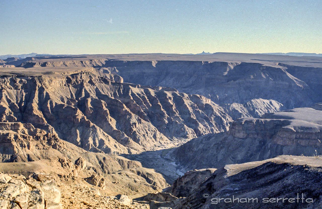
The following morning we set off for the Fish River Canyon, a short drive of 86 km. The canyon is the largest in Africa and second largest in the world, after the Grand Canyon in the USA. The plan was to climb down the 550 m to the river at the bottom, where we would picnic for the day and climb back up again before sunset. Man makes plans, and God smiles.......at man's foolishness!
 |
| At the canyon rim |
We made camp in the open on the canyon rim for the night so that we could start our climb down at sunrise. Supper was rump steak braaied over a fire made from dried cactus leaves. The temperature dropped to below freezing that night, as it does in the desert, and no-one slept very well.
 |
| Our camp |
Noelin and I slept in the back of the Opel with the back seat folded flat, and Fred slept on the front bench seat. Breakfast was prepared by Fred and Noelin - eggs, bacon, boerewors, coffee and toast. We would need the carbohydrates for the coming day. The sunrise was a spectacular sight and like all sunrises in the desert, over very quickly. No sooner had the sun breasted the horizon than it's heat reminded us of what was to come.
 |
| The Fish River Canyon |
The trail down the canyon wall was only marked for the first hundred yards or so, then it became very rough, with large boulders that had to be climbed over or around. It was an exhausting climb, going down is always more strenuous than going up, no matter where.

 |
| The climb down |
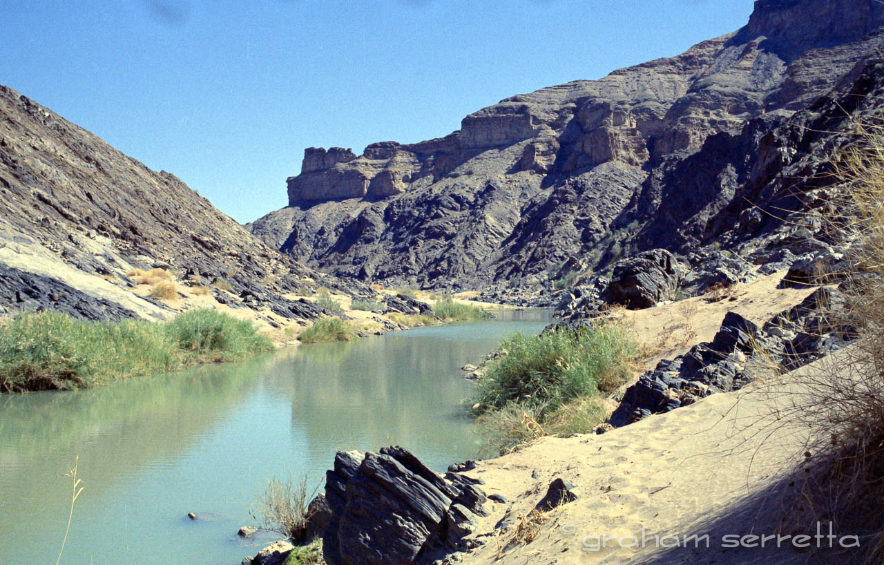
The climb down to the river at the bottom took us about three hours. The temperature was in the mid thirties. Fred insisted on carrying the food box as well as his Hasselblad camera outfit case. Once at the bottom, we rested for a couple of hours and ate a snack lunch. Fred had a swim in the river, which was not flowing but had formed big pools. The water was a deep green colour, indicating a probable high copper content, not algae.
 |
| The bottom at last |
As Noelin was three months pregnant she wouldn't risk swimming in it, and I just didn't trust the water to be crocodile free. Once rested, we started off the way we had come, but half way up we found ourselves in the middle of a scree slope. One pace up resulted in three back, and after struggling for two hours and getting nowhere, we were exhausted. I was starting to plan an emergency evacuation for Noelin, but how I would have accomplished that I didn't know.
 |
| We made it |
Fred cracked the whip and drove us on, not allowing us to surrender to our exhaustion, and carrying all of our baggage, leaving Noelin and I hands free! Through sheer will power, we struggled upwards until, just as the sun was setting, we achieved the top of the canyon rim.
 |
| The Fish River Canyon |
I had never felt quite so exhausted or drained of energy in my life, and then Fred conjured up a miracle. From his pack, he produced a tin of peach halves in syrup which he proceeded to open and using our fingers, we each ate a peach half, followed by another. Then we shared the syrup, and the result was miraculous. My energy levels returned just like fuel being pumped into a tank. We had left the car at the campsite, about a kilometer away, and the walk back was no effort at all.
 |
| The walk back to camp |
Another night under the stars around a campfire, made from dried cactus that Fred found in the surrounding desert where no wood existed. The stars of the milky way formed a sparkling roof over our heads that we could reach up and touch. We ate well and slept the sleep of exhaustion.
 |
| The road to Rosh Pinah |
The following morning, after another good breakfast, we packed up and hit the road. Now Fred's expertise came into play. He had been contracted by the De Beers diamond mining company to maintain certain water pump stations along the Orange river. Thus, Fred was totally familiar with the area around the "sperrgebiet" or "forbidden area" and had a permit to enter areas normally denied to others. He had arranged for us to have the use of one of the diamond mine’s guest cabins at Rosh Pinah, where he was normally based, for the night, and never has a hot shower felt so good. We ate a hearty supper in the mine staff canteen and Fred introduced us to some of his colleagues before we fell into very welcome beds.
 |
| Accommodation at Rosh Pinah |
The following day we drove across the desert, on very rough, unmapped roads, through a landscape that would have done an Apollo lander proud. The route took us through the "sperrgebiet".
The Sperrgebiet (German, meaning "Prohibited Area" and also known as Diamond Area 1) is a diamond mining area in southwestern Namibia, in the Namib Desert.
 |
| The sea is just over the hill |
It spans the Atlantic Ocean-facing coast from Oranjemund on the border with South Africa, to around 72 kilometres north of Lüderitz, a distance of 320 km north. The Sperrgebiet extends to around 100 km inland,and its total area of 26,000 km2, makes up three percent of Namibia's land mass. However, mining only takes place in five percent of the Sperrgebiet, with most of the area acting as a buffer zone.
 |
| The road to Alexander bay |
Members of the public were banned from entering most of the area. Fred would not allow me to take photographs, as this was forbidden in terms of his permit but I used the Nikon surreptitiously all the same. We saw some strange and astonishing sights, however, which I will never forget. In one area, we came upon giant Caterpillar bulldozers fitted with massive steel claws at the rear, with which they were ripping up the ground as they trundled along. The surface that they were ripping up was in fact a layer of concrete about six inches thick, which had been laid over many square kilometers of ground by the Allied authorities at the outbreak of the second world war as a security measure.
 |
Note the caterpillar track marks
in the sand |
 |
| The surface after scouring |
Believe it or not, the proliferation of diamonds was so great in some places that they could be easily harvested by scraping the top couple of cm off of the desert. Nazi Germany was desperate for a supply of industrial diamonds at that time and in order to prevent the Nazis from landing agents from submarines, to literally grab diamonds off of the surface of the desert, the richest areas were covered in concrete!
 |
| The drift over the Orange River |
It was this layer of concrete that we saw being ripped up and then scooped up by giant earth movers, leaving the surface of the desert flat sand once again, Caterpillar tracks in the sand remaining as the only evidence of man's interference. At first, Fred would not stop the car anywhere in this area as to do so would have invited immediate investigation had we been seen by the security helicopter which was constantly on patrol. By-passing Oranjemund, we travelled along the Orange river en route to Alexander Bay and were amazed by the swath of green agriculture on either bank.
 |
| 1950 |
There were vineyards, orchards, fields of wheat, barley, maize, orange orchards and even potatoes. Kilometer after kilometer. We finally joined the main tarmac road along the coast to Port Nolloth which was, and probably still is, a fishing port where fleets of commercial trawlers were based. Not very pretty and very smelly. We stopped for a bite to eat, and to re-fuel the trusty Opel. Noelin and I slept most of the way from there back to Springbok, and thence to Cape Town. Fred insisted on doing all the driving, which he did with confidence and skill.
It was a memorable trip, made the more so because of Fred’s knowledge of the area and his road skills. My research shows that there are now tourist hotels and lodges at The Fish River Canyon and that parts of the Sperrgebiet are to be handed back to the management of the Namibian tourist board as a nature reserve.
 |
| Refueling at Alexander Bay |
Diamond and mineral mining operations are still in full production. The Namib desert is a place that can infect one with a strong desire to return. One day we will.
Here is the whole story of the diamonds of the Sperrgebiet:
 |
| A Herero village |
 |
| The harbour at Alexander Bay |
 |
| The road home |


No comments:
Post a Comment
Keep it civil.